

We’re excited to announce the release of Civil Tools available through the Autodesk Docs Viewer in Autodesk Construction Cloud (ACC). With this launch, users can now perform infrastructure-specific design reviews directly within ACC. This new capability empowers stakeholders across the project lifecycle with tools to efficiently interrogate models, with an Autodesk Docs subscription.
This release is the first of many planned enhancements aimed at improving review workflows for civil designs.
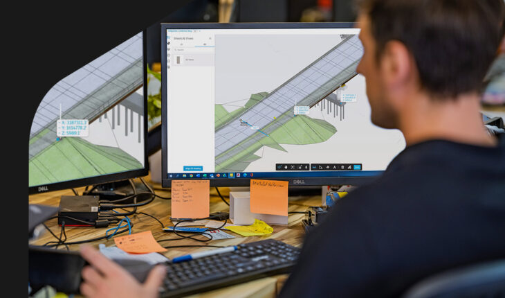
What’s included in this release of Autodesk Docs?
Alignment Stationing, Navigation, and Sectioning
- Select Centerline Geometries: Highlight and select 3D centerline geometries from Civil 3D drawings.
- Station Visualization: Visualize station labels along the 3D centerline and configure station formats to suit user preferences.
- Station Tracker: Track the current station’s position along the selected centerline.
- Sectioning Capability: Cut the 3D model perpendicular to the centerline at the current station for detailed analysis.
Spot Coordinates and Elevation Measurement
- Extract Coordinate Values: Identify and extract precise coordinate and elevation values from any point in the model.
Coming Soon: Station-Offset Measurements
- Obtain station/offset measurements relative to the selected centerline, including elevation data.
Civil engineers often face time-consuming design reviews due to a variety of challenges. These include extended model load times caused by complex drawings with large amounts of data, delays in feedback loops, miscommunication, and fragmented workflows stemming from the lack of a centralized source of truth. Accessing and managing design files with the right context, and doing so more efficiently, has become increasingly critical—and more achievable than ever before.
With Civil Tools, engineers can streamline design reviews by enabling all stakeholders to perform detailed assessments anytime and anywhere with Autodesk Docs. This eliminates the need to revert to authoring applications, enhancing both collaboration and efficiency.
The Civil Tools feature set also enhances the QA/QC process by democratizing design reviews. It provides all project stakeholders with access to critical model information without requiring specialized software, including linear design details. For example, project managers and BIM managers can perform detailed reviews and simple measurements and cross-section reviews, while QA/QC teams can create and assign issues directly within ACC. This fosters faster issue resolution and improved collaboration during coordination meetings.
Learn more
Autodesk is invested in empowering you across the project lifecycle to help you meet your infrastructure project goals. Get connected with us and the rest of the community by checking out the following:
Civil Infrastructure Public Roadmap
Looking for what’s new and what’s next for civil infrastructure features and capabilities? Check out the .
ACC Forum
Have a question about ACC? Take it to the and let the community of ACC users give you their tips.
ACC Ideas
Have an idea for making ACC better? Go to to find, post, and vote for the things you want to see in new versions of ACC.


